|
|
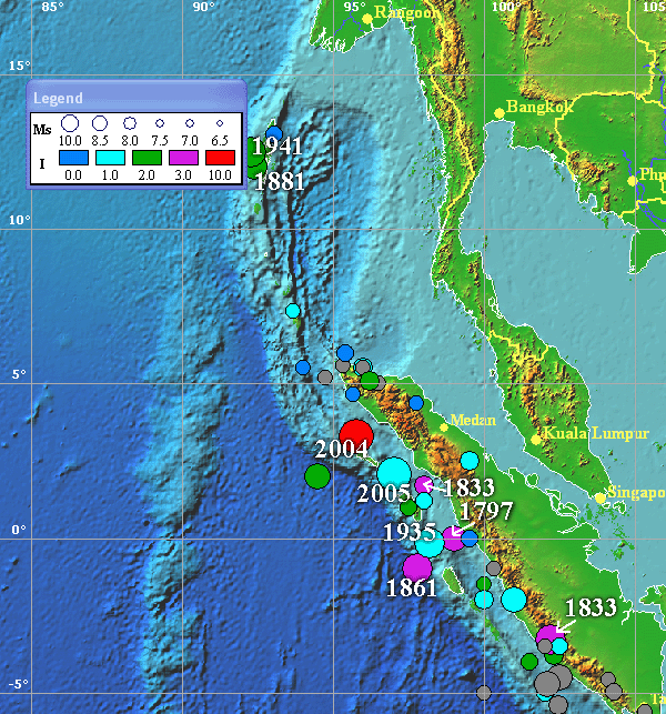
Historical tsunamigenic sources in the western Sumatra. The most destructive events are marked by years. Events with no quantitative values of tsunami intensity (due to the lack of run-up data) are shown in grey.
List of major tsunamis in the West of Sumatra - Nicobar/Andaman Islands area
| Date | Source | Lat | Lon | Ms | I | Hmax | Fat |
| 1797/02/10 | S of Nias | 0.0 | 99.0 | 8.0 | 3.0 | 5.0 | 300 |
| 1833/11/24 | SW Sumatra | -3.3 | 102.2 | 8.2 | 2.5 |
|
|
| 1843/01/05 | Nias I. | 1.7 | 98.0 | 7.5 | 3.0 | 8.0 |
|
| 1861/02/16 | S of Nias | -1.0 | 97.8 | 8.5 | 3.0 | 5.0 | 3000 |
| 1881/12/31 | Andaman Is. | 12.0 | 92.4 | 7.9 | 1.0 | 5.0 |
|
| 1883/08/27 | Krakatau | -6.1 | 105.4 | - | 4.0 | 36.0 | 36417 |
| 1896/10/10 | SW Sumatra | -3.5 | 102.5 | 6.8 | 1.0 |
|
|
| 1907/01/04 | NW Sumatra | 2.0 | 94.5 | 7.6 | 2.0 |
|
|
| 1935/12/28 | S of Nias | -0.2 | 98.2 | 8.1 | 1.0 |
|
|
| 1941/06/26 | Andaman Is. | 12.5 | 92.3 | 8.1 | 2.0 |
| 5000 |
| 2004/12/26 | NW Sumatra | 3.3 | 95.8 | 9.3 | 4.0 | 34.6 | 297728 |
| 2005/03/28 | NW Sumatra | 2.1 | 97.0 | 8.7 | ? | ? |
|
|