|
|
Historical seismicity for the northern coast of the New Guinea Island.
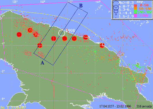
The map of historical seismicity for the northern coast of the New Guinea Island for the period 1857 to
1996. Altogether more 1300 events are shown with a half of them being recorded during the last 20
years. Solid circles show the position the large historical earthquakes listed in the table below. The white
circle shows the position of the July 17, 1998 event.
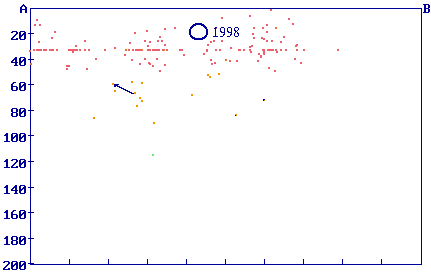
The vertical crosssection of seismicity pattern along the lines AB shown in the figure above. The white circle
shows the position of the July 17, 1998 event.
The level of background seismicity is quite moderate for this part of the Pacific rim. However, the
retrieval from the catalog of significant earthquakes (NGDC Report SE-49, 1992) shows the presence of
at least 9 major (with magnitude equal or greater than 7.5) earthquakes occurred near the source area of
the 1998 event since 1900. Their basic parameters are listed in the table below. Only two of them (events
of 1917 and 1935) have generated minor tsunamis.
List of historical earthquakes with magnitude larger that 7.5 for the north coast of the
New Guinea Island (retrieval from SIGN_EARTH catalog)
| Year | mo | da | ho | min | sec | lat | long | h | Ms |
| 1900 | 10 | 7 | 21 | 4 |
| -4.00 | 140.00 | 60 | 7.8 |
| 1916 | 8 | 3 | 1 | 30 |
| -4.00 | 144.50 | 60 | 7.5 |
| 1917 | 7 | 29 | 0 | 0 |
| -3.50 | 141.00 | 0 | 7.6 |
| 1918 | 7 | 3 | 6 | 52 |
| -3.50 | 142.50 | 60 | 7.5 |
| 1926 | 10 | 26 | 3 | 44 |
| -3.20 | 138.50 | 25 | 7.9 |
| 1935 | 9 | 20 | 1 | 46 |
| -3.50 | 141.80 | 60 | 7.9 |
| 1968 | 5 | 28 | 13 | 27 |
| -2.90 | 139.30 | 65 | 7.7 |
| 1968 | 10 | 23 | 21 | 4 |
| -3.40 | 143.30 | 21 | 7.5 |
| 1971 | 1 | 10 | 7 | 17 |
| -3.20 | 139.70 | 34 | 8.1 |
|
