|
|
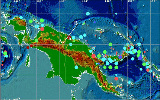
The epicenters of tsunamigenic earthquakes occurred in the New
Guinea region from 1768 to 1998 (65 historical events are
shown). The cursor shows the position of the July 17, 1998
event.
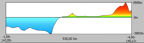
Vertical profile of the land and bottom surface along the line
AB shown in the figure above. Note the narrow shelf and the
steep continental slope in the source area of the July 17,
1998 earthquake.
The List of Historical Tsunamigenic Earthquakes occurred near northern coast of
the New Guinea Island (between 138E and 147E)
| year | mo | da | hr | mn | sec | latit. | longit. | h | Ms | I | Hmax | |
| 1873 | 3 | 0 |
|
|
| -5.50 | 146.00 | 0 | 8.0 | 2.0 |
| |
| 1907 | 5 | 7 | 10 | 16 |
| -2.80 | 144.50 | 33 | 7.1 |
|
| |
| 1907 | 12 | 15 | 17 | 35 |
| -3.10 | 142.50 | 33 | 7.3 |
|
| |
| 1917 | 7 | 29 | 21 | 52 | 24.0 | -3.05 | 143.80 | 33 | 7.5 |
| 1.00 | |
| 1930 | 9 | 30 | 21 | 20 | 45.0 | -4.50 | 146.00 | 33 | 7.0 |
|
| |
| 1935 | 9 | 20 | 1 | 46 | 33.0 | -3.20 | 142.50 | 60 | 7.9 |
|
| |
| 1951 | 2 | 22 | 1 | 45 | 42.0 | -3.60 | 142.60 | 33 |
| 1.5 |
| |
| 1970 | 10 | 31 | 17 | 53 | 9.3 | -4.90 | 145.50 | 42 | 7.0 | 0.5 | 4.30 | |
| 1971 | 9 | 25 | 4 | 36 | 14.0 | -6.54 | 146.57 | 115 | 6.3 | 0.5 | 1.80 | |
| 1998 | 7 | 17 | 8 | 49 | 15.0 | -3.08 | 141.70 | 33 | 7.0 | 2.3 | 10.00 | |
Historical tsunamis along the north coast of New Guinea
The tsunami of July 17, 1998 has occurred in one of the most remote and isolated part of the New Guinea coast.
This can be a reason that the little is known about historical tsunamis in this area. Possibly, one of strongest event
here happened in 1873 (Soloviev, Go, 1974). However, no quantitative data are available for this tsunami, that
could be destructive on the northeastern coast of the island. In this century, on 15 December 1907, at 17:35UT a
magnitude 7 earthquake hit the area west of Aitape (about 3.1S, 142.0E). Many details on this tsunami can be
found in H.Letz (1998) "Earthquake Hazard of Papua New Guinea", Dept. of Petroleum and Energy, Port
Moresby, in press. Prior to the earthquake, there was a small lagoon, called Warupu Lagoon with two small
islands inhabited by the Warupu clan. With the main earthquake, "a stretch of the coast of about 100 sq km
submerged into the sea forming a large lagoon". Today's Sissano Lagoon is about 26 km west of Aitape. The
water depth was estimated to be between 1.8 meters and 4 meters. It appears, that since the colonization by
Europeans the Aitape region had never before experienced any significant seismicity. Papua New Guineans
usually have their 'stories' explaining the creation of unusual landmarks which are passed on from generation to
generation. There is no story related to the creation of the Sissano Lagoon, which was only "recent. The NGDC
tsunami database also mentions tsunami generated by the 7.9 magnitude earthquake occurred on September 20,
1935 near the northern shoreline almost in the same area as the 1998 event. However, no tsunami intensity or
run-up heights are available in the database. To the east of the present event, 4 meter waves were observed after
magnitude 7.0 earthquake on October 31, 1970 near Madang.
|
