Tsunami Laboratory
Home
Tsunami General Info
Online catalogs
Regional tsunamis
Projects
Workshops
ITSU
ITIC
IUGG
Institute of Computational Mathematics and Mathematical Geophysics.

Novosibirsk,
RUSSIA,
pr. Lavrentieva, 6,
Tel:(3832)30-70-70
Fax:(3832)30-87-83 Email:gvk@sscc.ru

Inretgovernmental Oceanographic Commission

International Information Center Honolulu

logo

December 26, 2004 North Sumatra earthquake and tsunami
00:58:51 GMT Lat. 3.298S Long. 95.779E mb 8.5 Ms 8.9 Mw 9.3 Mt 9.1 I=4 Hmax=34.5m


Location map Source area Source data
Travel time map Tsunami warning Tsunami modeling
Historical seismicity Historical tsunamis Wave heights
Dependence I(Mw) Photos Fatalities
Tide-gauge record Post-event survey Related Web-sites

Location map of the Decamber 26, 2004 Sumatra earthquake and tsunami.
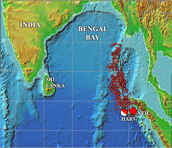
The location map of the December 26, 2004 earthquake. The large circle shows the positions of the main shock as determined by NEIC and HARV along with the first month aftershocks that roughly outline the earthquake source area. The main plate boundaries are shown in green.White rectangle outlines the area shown in the section "Source area"
Back